|
|
||||||||||||||
|
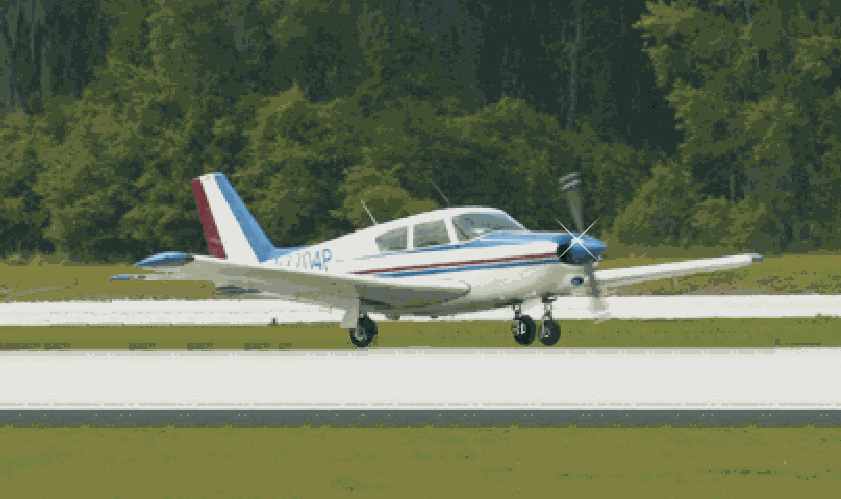
COMANCHES ON THE FLY Mike Dolin's Recent Vacation to San Francisco by Mike Dolin Prologue: Late in September of 2001, I flew from Kansas City to the San Francisco Bay area to meet friends, our own contributors, Omri Talmon and Joe Shelton. I returned home in early October. All of this mountain flying was done in a simple, run-of-the-mill, normally aspirated airplane - my Comanche 250. Just an ordinary 250, the most prevalent model of the PA 24 lineup. A few folks asked me to take notes along the way. My comments begin while riding in the plane at altitude, on oxygen. There's not much to do while up there so I write. In the following report, the paragraphs written in present tense are transcribed directly from my notes. Normally, my style is to fly VFR, not talking to anybody. I sit reclined in the airplane with autopilot on, sipping coffee or diet coke, listening to music and generally relaxing while viewing the scenery. In real weather conditions, I would be on an IFR flight plan, in which case the story of flight would be totally different. That doesn't mean I'm oblivious to the situation on board. I carefully monitor fuel, oxygen, the engine and navigational awareness in addition to the weather. For the most part, modern electronics has taken the work out of flying. Purdy near all the work, I almost regretfully say. I'm also glad to see that within our Comanche flying group, many folks are sharing stories of the recent flights they've made. To the non-aviator, even to the non-traveler it may appear just a measure of self-indulgence, this writing filled with alphabet soup. To all my friends, please don't feel that way. I love to read the travels and travails of other pilots and people and their interesting accounts en route. It makes me feel that writing my flying episodes is more than just a private diary only for myself, for I have done this ever since having a computer. Someday I'll pull them out and read what I did in younger years. I hope you do too.
This recent flight: I'm beginning with pen and pad over Utah. The Utah landscape is REALLY extreme, so much so that it reminds me to write. The sharp sculptured mountains are awesome. This could be Bryce canyon I'm looking at, for all I know. There are vertical shear rock formations, not at all different from big city skyscrapers. Wow! I'm truly amazed at this vast land of ours. As I rummage through the flight bag, I find I came without sectional charts, having left them on my kitchen table. CRS. It would be nice to know the names of mountain ranges and the altitude of peaks. The problem isn't in locating mountains and valleys for flight since I would fly VFR-direct at oxygen levels anyway, but they would really help me in writing the description. Whatever its name, this enormous canyon MUST be a national park. Present position is 30 DME north of Hanksville VORTAC (HVE) so I can look it up later. (Later I found out, from the Rand McNally atlas, it was Canyonlands National Park.) The countryside is pure desert. There could be some brush growing on hillsides, but nothing to call vegetation. Yet, despite this, the land is rich in color browns, reds and black shading in layers through the rock. The name Painted Desert comes to mind, but I know that's in Arizona. When I left in the early morning hours it was dead calm over the Kansas countryside. The flight is uneventful as I listen to music on the stereo. Then the abrupt change to rocky mountain terrain is eye opening. Colorado has the most rocky of the Rocky Mountains. It's actually scary going from flat land to such rugged landscape. At 16,500' the flight is barely above mountaintops. I passed right over Leadville. Some day, I must land there and pick up the certificate for landing at the country's highest airport. It's something I want to do in my lifetime. Near Aspen the turbulence became noticeable over the peaks, then smoothed off again in the hour before landing at Grand Junction, Colorado (KGJT) my fuel stop. It's a long-range machine, but I can't go the distance to SFO non-stop. This is about halfway. Half way. Logical, isn't it? Maybe not. I'll have to rethink my planning for the next trip west, and if I have time, break it up into two days for a stopover to drive around in a rental car. This part of the country has a flavor unknown to me. Grand Junction sits in a large valley nestled in the mountains along the Colorado and Gunnison rivers. (I read those names off of the GPS.) The runway is long and the service good at Timberline aviation. They even offer freshly baked chocolate chip cookies for pilots in their lounge. Flying over the local terrain, I begin to wonder what made settlers settle here in the first place. Perhaps this is all they could stand, going west, and figured it was as far as they wanted to go. I visited the Trails museum here in Kansas City and the Pony Express museum in St. Joe, MO in recent years. Ever since, I have marveled at the breed of travelers a century and a half ago. Just a quick glance out the window shows the character of landscape over which they traveled. What hardship they must have endured. It's the end of September and I must believe uncharacteristically hot for this time of year. Afternoon takeoff is in 80-degree heat. The engine starts easily and the takeoff roll is not unusually long, despite the thin warm air. The FAA Mountain Flying video I studied before leaving must apply to higher airports than Grand Junction. The trip has been smooth, off and on, until now. I'm in disbelief at the high temperatures and choppy air over the mountains. After climbing again to high altitudes it's just below 0C (30F), so says the outside air temperature (OAT) gauge, but the hot sun is still too warm in the cabin. I pulled out sunscreens to stick up on the windows. Ahead lay a row of cumulus clouds indicating smoother air aloft, so on up I go. Climb is slow without turbos. I got under one cloud looking for lift. It works, but 16,500' is as high as I go VFR. Alas, that's not high enough to outclimb either the cumulus or the turbulence. There's an immense, almost white, flat area ahead off to the right. Bonneville Salt Flats, is it? 32 DME north of Milford VORTAC (MLF 112.1). I'll look that up too, when I get back. The GPS says it is Sevier Lake (dry). Near Tonopah, NV I see a semicircle of terracing, much like a gigantic amphitheater. I notice buildings nearby. It can't be a theater, it's way too big. Perhaps it's a mining operation. Utah has the most sharply defined mountains and valleys, even though perhaps not the tallest of spires. Nevada is all desert but the terrain is not as harshly sculptured as Utah's. Colorado's peaks are the highest. Flight at 16,500' is smooth finally. It went in stages, moderate chop interspersed with areas of smooth air. Now, even over the mountains, it's smooth. On the final leg of the flight that day, it was terribly rough over a flat valley then dead calm over jagged mountain peaks. No, I don't know why, either. Mono Lake, it says on the GPS, just before a mountain ridge. OK, it's one lake! I can see that. The tallest peaks appear to be at my altitude. After passing south of the lake, the mountains slide under me just below the airplane. Off in the distance a giant rock looks like a wave about to break and fall over. Over the California valleys there is violent turbulence. Over the jagged peaks it's calm. Very strange wind currents. Indicated Air Speed (IAS) is 125 here. It helps to know weather when flying. I can tell I'm no meteorologist. I think I know just the basics. All the time from home base [New Century Aircenter (KIXD)] to 50 miles from the destination, it was easy 'ride-along and look-at-the-scenery' type of flying. Now, I get ready for the heavier workload during entry into the Bay area. Due to the current enhanced class B operations across the nation, I must pick up an IFR clearance to get into San Carlos (KSQL) airport. The plan was to file a compound flight plan, VFR and IFR from KGJT to KSQL, picking up IFR at Modesto. About 100 miles out I started to call for the clearance. Flight Service wasn't really sure what to do with me but said to call Center. ATC told me to pick up the clearance from somewhere other than where I filed. That's strange. During the conversation, one of the controllers finally said to expect transition over Manteca. I found it on the chart, a VOR, slowed the plane, the last thing I wanted to do when descending from altitude toward my destination, and called once again. I got one of the more complicated IFR clearances ever, for going into a VFR airport just a short distance away in VMC conditions. There should be a block on the flight plan to check if you are new to the area. Like, "Hey, guys, lighten up, I've never been here before." True to form, the path I flew and the initial clearance I received had little to do with each other. After some vectoring, I found myself headed almost north toward the airport. Well, if the inconvenience prevents terrorism, I'm all for it. I can't believe that the controllers want it either, all this IFR traffic into a field with essentially no instrument approach on a perfectly clear day. I landed and met Omri and Joe, whom I had come to see. Previously, I had spoken to both of them, plus we sent photos back and forth, but it was still an exciting treat to meet them face to face. Isn't it always a thrill to see the person on the other end of the e-mail address?
The Numbers: Pilots always want to talk about numbers. Altitude 16,500', OAT about 20F (or -12 to -14C). At full throttle the manifold pressure is a meager 15.5". RPM is set at my normal; about 2325. The indicated air speed, ranging from 125 down to 115, depends upon up or down drafts. (I'll wait for you, my fellow pilots to tell me what the True Air Speed range was.) All gauges are running cool, especially carb air at an unbelievable minus 40. Oxygen flow is 3 LPM, whatever that means. Never quite understood oxygen flow by the numbers, I just set the flow for feeling comfortable. Today I'm carrying four E-size bottles. That's plenty. Oxygen is like fuel. You just can't never have too much. Ground speed is up and down. I know I started with a remarkable 170 mph going west out of Kansas City. From Grand Junction, it fluctuated from 133 mph to 145 or so. The fuel timers have long since timed out for two separate tanks, yet the gauges read between 1/4 to 1/2. The engine just sips fuel up here. Fuel Quantity? I don't know. I could look at the receipts if I saved them. Long ago, like 25 years previous, I had studied the fuel burn and measured carefully to the tenth of a gallon per hour. Now I plan long-range flights quite differently, roughly estimating gallons per hour, which depends so heavily on weight and altitude en route. Of course I have the luxury of flying over this country, where airports abound and the modern GPS is so eager to point them out. If I ever flew across other countries or stretches of water, you can bet I'd plan more carefully. The flight from KIXD to KGJT is 4.8 hours. From KGJT to KSQL, another 4.5. Just over 9 hours that first day. ++++++++++ San Fran-Cisco: I had so looked forward to seeing San Francisco. I wanted to hear the clang of the cable cars, cross the famous Golden Gate Bridge and feast at Fisherman's Wharf. I envisioned seafood and sourdough while enjoying the salty pacific breezes. These things I missed, but I did indulge in sinfully rich chocolate at Max's in Palo Alto, thanks to old friends, Claude and Norma, who live there. During the day, Saturday, we visited the Hiller museum on San Carlos airport. It has the Boeing SST mockup and of all things, the racer used in Star Wars, Episode I. Aside from the many Hiller helicopters there are quite a few well-restored airplanes to see. It shows the Californian early days of flying, the likes of museums in every location around the country. Possibly even, around the globe. Saturday evening we flew to Harris Ranch (3O8) for steaks in Claude's Mooney. As he pointed out, it pains me to admit at least 10 knots faster than my Comanche, with its 300 horse Continental IO-550 up front. Harris Ranch is a wonderful fly-in steak house about an hour south of San Francisco in the California desert. The runway is parallel to and near California's Interstate 5 where it crosses highway 198. I don't see any familiar city or town nearby to say better where it's located. Do you all know about where Coalinga is? I want to add that I used the GPS 295 to find Claude's house and my return route across the bay to San Carlos airport. It contained the telephone number of the car rental agency on the land data chip. It found a 'nearest' gas station when there appeared to be none around. Not everybody loves this electronic gadget so, but I have come to rely on it. I just cross my fingers when I want to look up a particular restaurant or address, hoping it is one of the many listed. Due to a shift in plans, I moved the plane to Hayward airport (KHWD) on Sunday. The IFR flight between two airports just 12 miles apart took half an hour due to the convoluted routing. The track history line on the GPS looks like a piece from a jigsaw puzzle. That and Avgas pushing upwards of $3 a gallon is enough to make a local pilot take up knitting. Tune in next month, perhaps, for the adventure of the return trip.
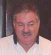
Mike Dolin is a 6000 hour CFI with instrument and multi ratings who currently lives in Kansas City. He has owned his Comanche 250, N7704P, for 28 years and has criss crossed the nation east and west, north and south through good weather and bad. |
||||
|
|
||||